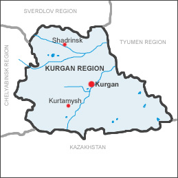
 The Kurgan region is situated in the
south-western part of the West Siberian Plain, in the catchment basin
of the middle stream line of the Tobol. This river is also called the
Gates of the Siberia.
The spatial extent of the region from
West to East is 430 km, from North to South is 290 km. The Kurgan region
takes the area of 71,5 thousand square kilometers.
The Kurgan region is situated in the
south-western part of the West Siberian Plain, in the catchment basin
of the middle stream line of the Tobol. This river is also called the
Gates of the Siberia.
The spatial extent of the region from
West to East is 430 km, from North to South is 290 km. The Kurgan region
takes the area of 71,5 thousand square kilometers. The Kurgan region boarders on the Yekaterinburg region in the north and in the north-west, on Chelyabinsk region — in the east and in the south-west, on Kazakhstan in the south and south-east, on the Tyumen region — in the east and in the north-east. The Kurgan region is situated on the Trans Siberian line, which connects our region with it's the most important economic centers in European and Asian parts of the country and especially it tightly connects our region with Ural.
The geographical position of the region
is favorable to its wide economic contacts with the regions of the middle
and south Ural and western Siberia, to usage of the Ural metal, of oil
and gas of Tyumen, to usage of Siberian-Kazakhstan coal.
The population is 1,054,100 people (for 01.01.2004) and 41,4% live in towns.
The region consists of 24 districts including tow cities (towns) of oblast subordination: Kurgan, which is the regional center and Shadrinsk (it has become a town since 1737); 7 towns 0f regional subordination: Dalmatovo (since 1947), Kataisk (it is founded in the middle of the 17-th century, it is a town since 1944), Kurtamysh (since 1956), Makushino (since 1963), Petuhovo (since 1944), Shumiha (since 1944), Schuchye ( since 1945); 6 settlements. It is separated from the Chelyabinsk region on the 6-th of February in 1943.
